Overview of 2021 Fires in Southern BC
Shown here outlined in orange are the major southern BC fires mapped for this work. We will explore some of them in more detail below.
Sparks Lake Fire
Size: 89,627 ha
Discovered: June 28, 2021
Cause: Under investigation (human suspected)
The Sparks Lake Fire was the largest wildfire of the 2021 season.
The fire started north-west of the city of Kamloops, and prompted evacuation orders for residents in the Thompson-Nicola Regional District.
While the cause remains under investigation, it is suspected to be human caused.
The fire was finally brought under control in early September after burning an area of over 900 square kilometres.
Continue scrolling to see before and after imagery as well as burn severity data for this fire. Use the "Next Fire" button to skip to the next fires.
Sparks Lake Fire - Before
Image Source: Sentinel-2
Image Date: June 26, 2021
Sparks Lake Fire - After
Image Source: Sentinel-2
Image Date: September 07, 2021
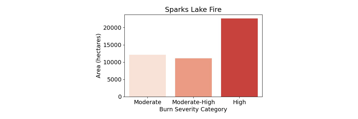
Sparks Lake Fire - Burn Severity
This map shows the burn severity for the Sparks Lake Fire. The chart below summarizes the area in each burn severity class.
Lytton Creek & Mowhokam Creek Fires
Lytton Creek Fire:
Size: 83, 740 ha
Discovered: June 30, 2021
Cause: Under investigation
Mowhokam Creek Fire:
Size: 5098 ha
Discovered: July 9, 2021
Cause: Lightning
The Lytton Creek fire was the 2nd largest and the most infamous fire of the 2021 fire season.
The incredibly warm and dry conditions along with high winds allowed the fire to rapidly advance on the village of Lytton, leaving residents little time to evacuate.
The fire destroyed 90% of the village and tragically caused the deaths of two people.
The Lytton Creek fire was declared under control on September 4, 2021. The cause of the fire remains under investigation but it is believed to have been human-caused.
South of the Lytton Creek fire, the much smaller Mowhokam Creek Fire burned an area around Jackass Mountain, just to the East of the Trans-Canada Highway.
Continue scrolling to see before and after imagery as well as burn severity data for this fire. Use the "Previous Fire" and "Next Fire" buttons to skip between fires.
Lytton Creek & Mowhokam Creek Fires - Before
Image Source: Sentinel-2
Image Date: June 29, 2021
Lytton Creek & Mowhokam Creek Fires - After
Image Source: Sentinel-2
Image Date: September 07, 2021
Lytton Creek & Mowhokam Creek Fires - Burn Severity
This map shows the burn severity for the Lytton Creek and Mowhokam Creek fires. The charts below summarize the area in each burn severity class for each fire.

White Rock Lake Fire
Size: 83, 343 ha
Discovered: July 13, 2021
Cause: Lightning
The White Rock Lake fire was the 3rd largest wildfire of the 2021 season.
It burned on the west side of Okanagan Lake, directly west of the city of Vernon, and prompted evacuation orders for over 900 properties in the central Okanagan region.
The fire burned through the community of Monte Lake, damaging and destroying many properties.
It was finally declared under control on September 03, 2021.
Continue scrolling to see before and after imagery as well as burn severity data for this fire. Use the "Previous Fire" and "Next Fire" buttons to skip between fires.
White Rock Lake Fire - Before
Image Source: Sentinel-2
Image Date: June 26, 2021
White Rock Lake Fire - After
Image Source: Sentinel-2
Image Date: October 04, 2021
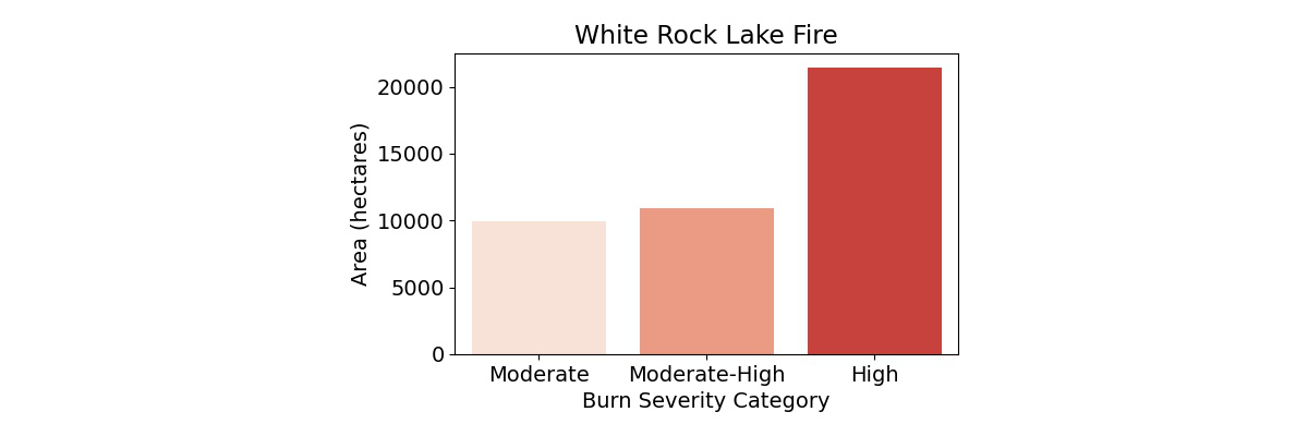
White Rock Lake Fire - Burn Severity
This map shows the burn severity for the White Rock Lake Fire. The chart below summarizes the area in each burn severity class.
July Mountain Fire
Size: 19,080 ha
Discovered: July 13, 2021
Cause: Lightning
The July Mountain fire burnt near the Coquihalla Highway between the towns of Hope and Merritt, one of the busiest transport corridors in BC. Beginning on the west side of the highway, it jumped across to burn on the east side as well. The fire was declared held on September 07, 2021.
Continue scrolling to see before and after imagery as well as burn severity data for this fire. Use the "Previous Fire" and "Next Fire" buttons to skip between fires.
July Mountain Fire - Before
Image Source: Sentinel-2
Image Date: June 29, 2021
July Mountain Fire - After
Image Source: Sentinel-2
Image Date: September 07, 2021
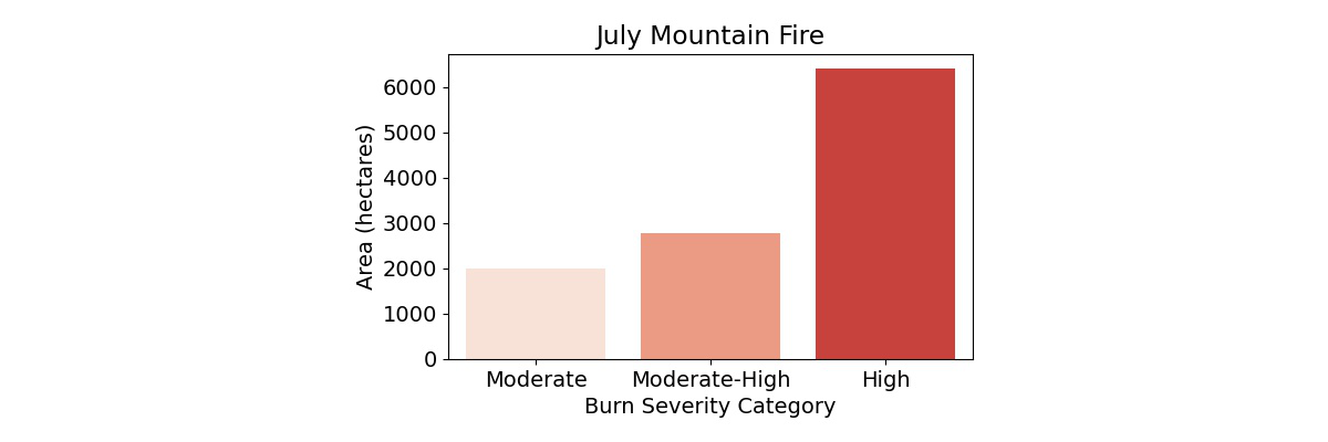
July Mountain Fire - Burn Severity
This map shows the burn severity for the July Mountain Fire. The chart below summarizes the area in each burn severity class.
Tremont Creek Fire
Size: 62,524 ha
Discovered: July 12, 2021
Cause: Under investigation
The Tremont Creek fire burned to the south-east of the town of Ashcroft and directly north of the District of Logan Lake, causing an evacuation order for nearby residents.
The fire was declared under control on August 26, 2021.
Continue scrolling to see before and after imagery as well as burn severity data for this fire. Use the "Previous Fire" and "Next Fire" buttons to skip between fires.
Tremont Creek Fire - Before
Image Source: Sentinel-2
Image Date: June 26, 2021
Tremont Creek Fire - After
Image Source: Sentinel-2
Image Date: September 07, 2021
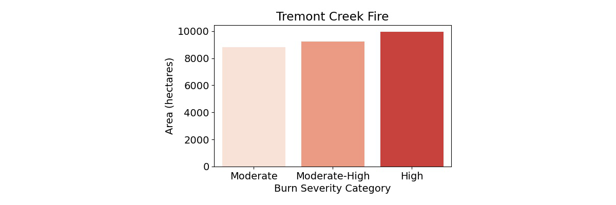
Tremont Creek Fire - Burn Severity
This map shows the burn severity for the Tremont Creek Fire. The chart below summarizes the area in each burn severity class.
Flat Lake Fire
Size: 74,194 ha
Discovered: July 08, 2021
Cause: Lightning
The Flat Lake Fire occurred to the Southwest of 100 Mile House, prompting evacuations in the Cariboo Regional District.
It was declared under control on August 27, 2021.
Continue scrolling to see before and after imagery as well as burn severity data for this fire. Use the "Previous Fire" and "Next Fire" buttons to skip between fires.
Flat Lake Fire - Before
Image Source: Sentinel-2
Image Date: June 29, 2021
Flat Lake Fire - After
Image Source: Sentinel-2
Image Date: September 07, 2021
Flat Lake Fire - Burn Severity
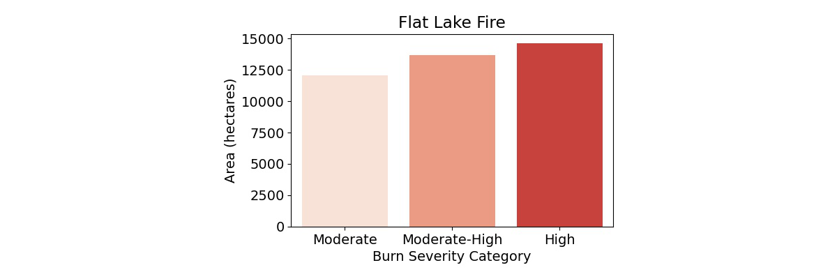
This map shows the burn severity for the Flat Lake Fire. The chart below summarizes the area in each burn severity class.
McKay Creek Fire
Size: 44,964 ha
Discovered: June 29, 2021
Cause: Suspected human caused
The McKay Creek fire burned directly north of the town of Lillooet, causing evacuation orders within the Squamish-Lillooet Regional District.
The fire was declared under control on September 1, 2021.
Continue scrolling to see before and after imagery as well as burn severity data for this fire. Use the "Previous Fire" button to return to the previous fires.
McKay Creek Fire - Before
Image Source: Sentinel-2
Image Date: June 29, 2021
McKay Creek Fire - After
Image Source: Sentinel-2
Image Date: September 07, 2021
McKay Creek Fire - Burn Severity
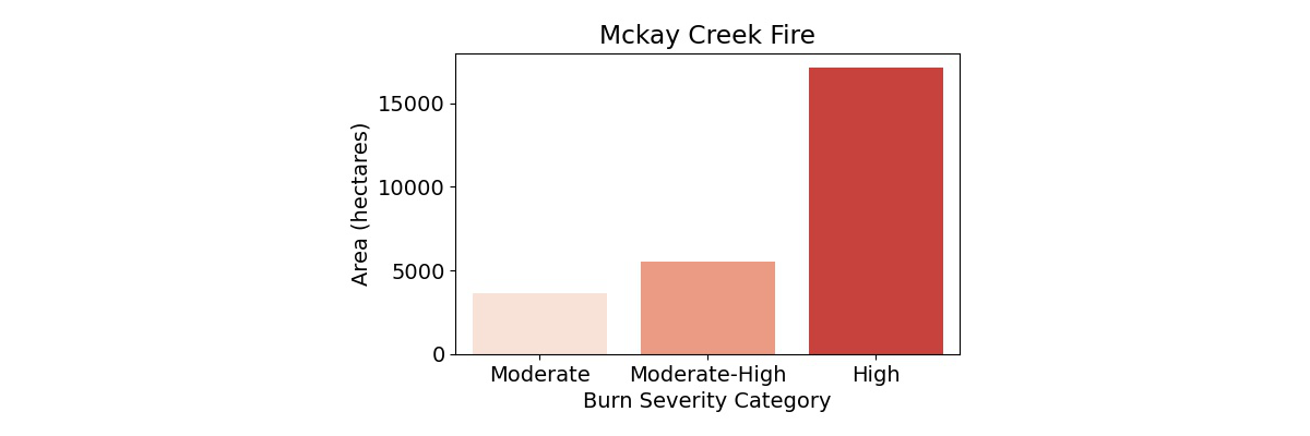
This map shows the burn severity for the McKay Creek Fire. The chart below summarizes the area in each burn severity class.
River Basins and Fires
Two of the largest drainage basins in BC are the Thompson River basin and the Fraser River basin.
The Thompson River is the largest tributary to the Fraser, joining with it at Lytton. From there, the combined waters from both rivers move southwest, discharging into the Strait of Georgia south of Vancouver.
Most of the fires we mapped were within the Thompson River basin. If wildfires produce an enhanced flood risk, we would expect the impacts to be felt primarily in the Thompson basin; however, since the Thompson drains into the Fraser, areas along the Fraser downstream of Lytton may be impacted also.
